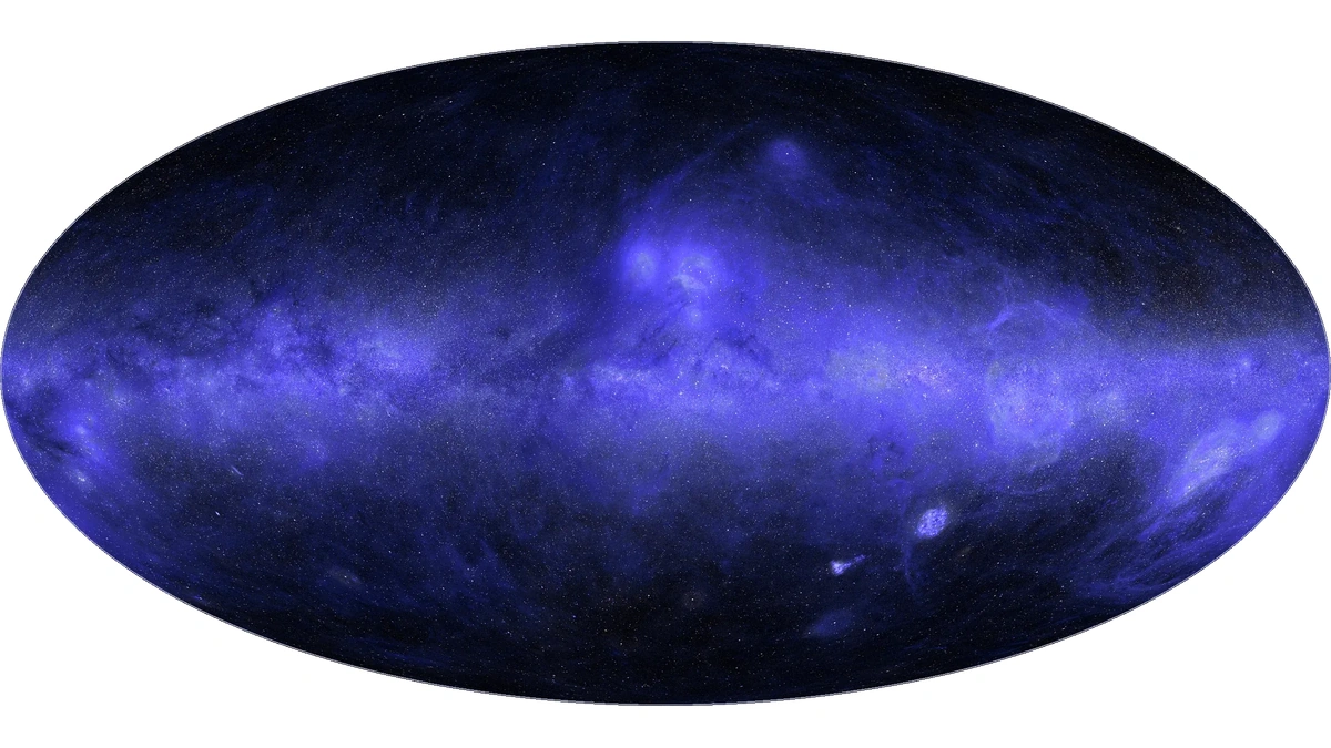
Claude Science has produced what Anthropic describes as the first complete map of the sky in ultraviolet light, including the roughly one-third of the sky that no UV telescope has ever observed. Brice Ménard, an astrophysicist at Johns Hopkins University and a researcher at Anthropic, directed the work over several days this summer.
The gap existed because ultraviolet light is absorbed by Earth's ozone layer, so every UV survey has to fly. In his account for Anthropic, Ménard says NASA's GALEX mission covered about two-thirds of the sky between 2003 and 2013 in some 38,000 observations, but deliberately skipped fields with very bright stars, including much of the Milky Way's plane, to protect its detectors. Swift and South Korea's FIMS/SPEAR added data, yet holes remained. Statistical methods for filling them are known, but he describes the calibration as weeks of pixel-level work that researchers rarely prioritize.
Ménard gave Claude Science a plain brief: gather every public UV dataset, put them on one scale, merge them, and fill every unobserved patch. Claude then coordinated a team of agents, a design that fits the broader pattern of AI agents splitting a large job into parallel parts. Different agents downloaded the surveys, removed star glare, cross-calibrated instruments and redrew everything at one resolution on a shared coordinate system.
For the missing third, Claude Science used inpainting, a machine learning technique that restores absent image regions from their surroundings. It also learned how UV brightness tracks visible, infrared and radio observations across the mapped two-thirds, then applied that relationship to the blank areas. To test it, Ménard had Claude hide parts of regions with real UV data and reconstruct them; the estimates landed within about 10% of the measurements. Estimates for more than 100 million individual stars, inferred from visible-light data from the European Space Agency's Gaia satellite, were layered on top.
Claude Science did not get everything right on the first pass. Ménard spotted faint circles in some of the dimmest fields, the footprints of single GALEX exposures carrying leftover atmospheric glow. Claude had listed the issue at the start, and the map still passed two rounds of review by other agents. A human eyeballing the images caught it, after which Claude corrected the glow across all 38,000 observations in a couple of hours. For anyone leaning on agent-to-agent review, that is the useful detail.
The published map labels each pixel as measured or predicted and adds uncertainty layers, so a reader can tell observation from model. Ménard pitches the Claude Science map as a teaching tool, with about a third of the image, much of the galactic plane included, being a model prediction rather than a new measurement, built with generative AI methods.